


cotes d'arey St sorlin par vernioz

marc6262
User
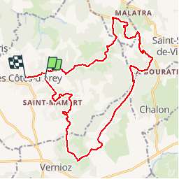

Length
21 km

Max alt
424 m

Uphill gradient
484 m
Km-Effort
27 km

Min alt
267 m

Downhill gradient
472 m
Boucle
No
Creation date :
2014-12-10 00:00:00.0
Updated on :
2014-12-10 00:00:00.0
3h14
Difficulty : Medium

FREE GPS app for hiking
 SityTrail
IGN / Geographical institutes
SityTrail Plus
The world is yours!
About
Trail Mountain bike of 21 km to be discovered at Auvergne-Rhône-Alpes, Isère, Les Côtes-d'Arey. This trail is proposed by marc6262.
Positioning
Country:
France
Region :
Auvergne-Rhône-Alpes
Department/Province :
Isère
Municipality :
Les Côtes-d'Arey
Location:
Unknown
Start:(Dec)
Start:(UTM)
646777 ; 5035340 (31T) N.
Comments